Tuesday, October 25, 2011

All Vocab list


Quiz #2
7.3
aeolian - also known as wind
spinifex - a type of grass that 'traps' sand
constructive waves - waves that push the sand back to the beach
corrasion - occurs when waves crash over rock shelves and move rock and other material helping to erode the rock shelf away
corrosion - the action of salt on minerals like iron that are contained in rock, weakening the rock and making i more susceptible to erosion
refraction - the bending of waves around headlands and into bays
deposition - the depositing of sand and rock particles caused by wind and wave action forming features such as beaches
destructive waves - large waves formed by tropical cyclones and storms that erode material from beaches
erosion - the removal of rock and sand particles as a result of wind and wave action
hydraulic action - where waves enter cracks in rocks, air is compressed y the force of the water causing erosion and forming features such as blow hole
longshore drift - when waves come in on an angle and push the sand to one end of the beach

Quiz #3
7.4
erosion-accretion cycle
groynes -
revegetation -
sea walls -

7.5
rock wall
beach nourishment
sand bar

7.7
environmental impact study -
impact assessment -

Quiz #4
7.8
bitou bush -
marram grass -  
noxious weed -  
foredune

hind dune
tertiary species
fore dune
off-shore bar
incipient dune
beach berm
secondary species

7.9
anemometer -
hygrometer -

Monday, October 17, 2011

Homework - Bombora

Bombora is an Aboriginal term for an area of large waves breaking over a shallow area such as a submerged rock shelf, reef or sand bank that is located some distance from the shoreline and beach surf break.

As the wave passes over the shallow area its shape is raised and steepened, creating a localized wave formation. The size and shape of the Bombora waves make them attractive to surfers. They can be quite dangerous to surf on because of the size and the shallowness of the water over a submerged rock shelf or sand bank/bar.


Bombora waves are formed far out at sea, this is known as ground swell. They start off as ripples caused by the wind and slowly become bigger as they come to shore. As the energy hits the rock shelf or sand bar, it gets pushed up causing the wave to suddenly rise and making the waves very big.

The conditions that make the Bombora waves are the biggest is: storm far out to sea previous days, and high tide also makes the waves bigger. Bombora waves are quite rare and only happen in certain parts of the world.


The picture below shows a typical bombora spot. At Queenscliff near the headlands you can see a submerged rock platform and this pushes the wave up to its unique shape.


http://www.youtube.com/watch?v=kr9yN4qFLP4

the video link above ^^ is of some bombora waves. They people bodyboarding the waves are 14 kilometres out to sea on a shallow reef. The wave is massive, 15-20 feet but not very wide. The wave only forms over the reef which isn't very wide either. At 2:15 you can see that the wave ends very suddenly and this is because the reef finished and drops back down to the bottom of the ocean.

The Science of Big Waves

1. They are formed by wind and start off as little ripples and begin to get bigger until they reach the shoreline and break.
2. Where it is going to break on the wave, where it is going to break in relation to distance in front or behind the surfer.

1. The wave has a sort of peak and it breaks there, causing a very steep drop on the wave, but the barrel is very thin and hard for the surfers to get in.
2. They are formed by a high and low pressure system in the arctic ocean, you need fetch, wind speed and how long the wind has been blowing for the waves to become good.
3. They are formed because of the rocks on the ocean floor acting like a speed bump. It breaks on a reef causing the peak like formation.
4. The energy is more concentrated on the headlands, or the point. The energy of the wave is beneath it and when it comes closer to shore the ocean floor pushes all the energy up making the wave bigger.
5. 'To run in there and catch a wave before you get taken by the wrath of God'

Sunday, October 16, 2011

7.3 Questions

1. Erosion, transportation and deposition.
2. Wave refraction is when the waves energy is refracted causing the wave to be more concentrated in certain areas compared to others.
3.


4.Around the headlands is when erosion most occurs.
5. Hydraulic Action, corrasion and corrosion.
6. Erosion-accretion cycle is when the sand is taken away by big waves and then it forms a sand bar, then the waves slow push the sand back into place on the beach making it a cycle.
7. Wind, waves and ocean currents
8. Beaches
9. Wind causes the sand to travel towards inland but then it gets trapped by low-lying vegetation. Over time this will cause a sand dune
10. The waves come in on an angle and push the sand to one side of the beach.
11. Headlands - Hydraulic Action, corrasion and corrosion all have a part in eroding the headlands
Wave cut platform - hydraulic action, corrasion and corrosion all 'cut' through the cliff making a platform
Beaches - long shore drift, destructive waves, erosion-accretion cycle
Sand dunes - the wind causes the sand to go inland and this can cause a dune to form
12. It provides a buffer zone for the fragile plant life.
13. a. located off the great ocean road in Victoria
b. they have been there for roughly 20 millions years
c. They were created by the sea gradually eroding the soft limestone cliffs.
d. The London Bridge was an arch made of rock that collapsed in 1990.
e. Maybe. If barriers were placed around the apostles then it may prevent them from collapsing or a break wall or something. This would take a long time and a lot of money so it is unlikely.
14. The 12 apostles behind me are from rock formed up to 20 millions years ago. They were created by the sea gradually eroding the soft limestone cliffs. Eventually all of these will fall down if action is not taken towards them.

Tuesday, October 11, 2011

7.1 Questions

1. 85% of the Australian population live on the coast.
2. It is the aim of coastal management strategies to keep the development of the coastline sustainable because they want future generations to be able to have no worries in living on the coast.
3. When people move from the city and start a new life near the sea
4. the government have made the population cap of towns up.
5. Pollution - people not using their rubbish properly, carbon emissions from cars
Population Growth - sea change, people want better work
Tourism - people are becoming more familiar with the world and want to travel more.
6.

7.2 Questions

1. The wind forms ripples, then wavelets and then finally waves.
2. The distance the wind travels over the ocean to form a wave is called the fetch.y the strength of the wind and the size and speed of the waves is influenced by the length of the fetch.
3. When the waves get closer to shore they start to interact with the floor.
4.
5.
6. Spilling waves: break far from the shore with gentle slopes.
Plunging waves: break on the beach with a moderately steep slope.
surging waves: toll up the steep face rather than breaking over it, cause erosion
7. A wind swell is marked by a short wavelength and high frequency of waves hitting the coast. A ground swell forms when waves have traveled across a greater distance of ocean before hitting the coast. A ground swell has a longer wavelength and the waves hit the coast less frequently.
8. It was out at sea for 36 hours, and then it hit the Queensland coast. From 5am March 20 to 9pm March 21 it went through Queensland and destroyed a lot of home, buildings, farmland, etc.
9. There are three different types of waves: spilling waves, they break far from the shore and are probably the best for swimming at the beach. Plunging waves, they break on beaches with a moderate slope and form a tube, these are good for you if you like to board ride. Surging waves, roll  up the beach instead of breaking onto it.
10. The waves were all calm on the first day and it looked as if there was no problem, but the second day everything changed. The waves were massive and a lot of seaweed and debris had washed up on the beach, the weather was horrible with the grey clouds above and no one on the beach. The cyclone was about 10 kilometres off shore and it was very very windy. The rain came without warning and hit the window of the lifeguard tower like a bullet. The waves were getting even bigger than I imagined and then it hit. The wind was enormous and the rain hurt when it hit you. The next day debris was everywhere and the streets covered in silt.
Quiz #1
7.1
breakwaters - A barrier that protects a harbor or shore from the full impact of waves.
silting - A sedimentary material consisting of very fine particles intermediate in size between sand and clay
sea change - when people move from the city to start a new life by the sea


urban stormwater - stormwater that can contain sediment, bacteria, heavy metals and organic chemicals into the ocean.


silting - when a floor bed gets covered with silt


tidal flushing - an action of saltwater estuary during high tide twice a day

dredging - Clean out the bed of (a harbor, river, or other area of water) by scooping out mud, weeds, and rubbish with a dredge.


introduced plants - plants that have been introduced from other countries.

7.2
ground swell - when waves travel a longer distance of ocean before hitting the coast.
plunging waves - break on the beach where the slope is moderately steep.
spilling waves - break far from the shore with gentle slopes
surging waves - occure on steep beaches, the waves roll up the steep face reather than breaking over it, causing erosion.
wind swell - when waves travel only a short distance of ocean before hitting the beach.
wave height - the vertical distance between the trough and the peak of a wave
wavelength - the horizontal distance between wave peaks
fetch - the distance that wind travels over the ocean to form waves
surf and swash zone - The area where the waves break.

Tuesday, September 6, 2011

Page 113 1-11

1. Drought has a massive impact on the community. Drought causes economic hardship for the agricultural population, which has an effect on businesses, jobs and the local economy of the town.
2. When the soldier settlement was sold no profit was made when started a recession
3. The selling of the soldier settlements, the collapse of the wool industry, and the cost of living has increased.
4. Machines have replaced many employed people making them unemployed because they work faster and eventually cheaper.
5. Better roads have made the decline of Gulargambone even worse. New roads have connected the bigger towns/cities together and now cut out small country towns making the tourism worse. Most people don't want to live in small country towns for many reasons such as facilities and particularly entertainment.
6. Population, Ageing population and a loss of services for the people who remain in the community.
8. In 1954 the population was 900 and it declined very fast in the net 10 years down to 400. It has stayed steady until now.
9. 
10. a. The school enrollments raised to 325 in 1960 but it has slowing gone downhill since then and how less then 100 people go to the school.
b. This has probably happened because of rural decline and families wanting their children to have better education and better living.
11. Social: Rural decline has cause lots of families to leave to go to the cities and major country towns.
Economic: Lots of machines have taken over the employed people.
Environment: The drought has caused lots of businesses to lose money and jobs have been lost.

Monday, September 5, 2011

Page 109 1-7, 8b, 9a-d, 10

1. Rural decline is when people migrate to urban areas from rural areas.
2. It is located on the Castlereagh River, half-way between Gilgandra and Coonamble in the central west region of New South Wales. 115 kilomtres north of Dubbo.
3. Has a temperate climate with periods of extreme heat in the Summer. The terrain is flat to undulating and the soils are fertile black and red types.
4. After World War II the Australian Government split the town into smaller blocks for returning soldiers.
5. Agriculture, Forestry, Population, Indigenous population, Tourism, Community events.
6. 447 people and 1072 in the surrounding areas
7. CDEP is Community Development Employment Project
8b) i) north west
ii) north north east
iii) north west
9a) i) 14818 3118
ii) 14816 3124
iii) 14820 3115
b) i) 62 53
ii) 63 53
iii) 61 51
c) i) 2km
ii) 5km
d) i) mainly forest but not many buildings not very dense
ii) railways, building very dense

Sunday, September 4, 2011

Geography Preliminary - 2006

Source A-C
1. 0.7%
2. 60 million
3. Africa

Source D
1. 0.8 million males, 0.8 million females
2. 1.3 million males, 1.8 million females
3. Living in Italy would be much easier in Ethiopia. Death would occur much younger in Ethiopia than in Italy.

Source E
1. Dicks Hill
2. Camden Haven
3. 10 metres
4. Sewage Works
5. Approx. 1km
6. GR831001
7. Laurieton at 79m GR848986

Go back to where you came from reflection

My first reaction to the series of 'Go Back to Where You Came From' changed to my reaction at the end of the series. At first I was very against refugees coming and staying in Australia but now I believe that some refugees should be allowed to stay in Australia. The plot of people going in a backwards refugee cycle was a bit weird but it makes sense, getting the people ready for the future refugee camps in Jordan and Kenya.

1. 1.5%
2. Lots of chaos has risen from asylum seekers and refugees because of multiple reasons. Some of these include poor living conditions and isolation.
3. 15th
4.
5. The same
6. 11
7. It means that refugees from Malaysia can't leave.

Monday, August 22, 2011

Australian Facts and Stuff


1. What is demography?

Is the study of human population.

2. In what year did the Australian population reach 20 million? How quickly is the population growing?

December 4 2003 and it is rising very quickly with lots of immigrants coming in.

3. How many Aboriginal people are estimated to have lived in Australia before Europeans arrived?

at least 750,000

4. What the two main ways the population can grow? What percentage of the population growth in 2010 can be attributed to each way?

immigration and birth rate.

5. What is the total fertility rate for 2010?

1.2 per woman

6. What was the total fertility rate for Australia in 1935? How does this compare to other years? 7. Why do you think that it compares this way?

2.1 per woman

8. What is the trend in the fertility rate for Australia since 1950?

it has shrunk dramatically and the population is growing slower than before.

9. What is the average size of a family in Australia? How does that compare to the US?

2.6 children in AUS, and in the US it is 2.6 very much the same

Tuesday, August 16, 2011

Are we a racism nation?

1. Who is the author and what is his job title?

Graeme Innes and his job title is disability and race discrimination commissioner.

2. Who does he work for and what is supposed to do in this job?

Australian Human Rights Commission in his job he has to do work with: same-sex: Same Entitlements Inquiry, achieving removal of discrimination across federal law; drafting of the United Nations Convention on the Rights of Persons with Disabilities, and ratification by Australia; three inspections of Australia's Immigration Detention facilities; and development of a National Disability Strategy.

3. What does the author say is often the beginning of a racist comment? Have you every heard anyone use this line to say something racist? If so, what did they say?

yes. I'm not racist but... asians are crap drivers.

4. What percent of Australians are born overseas or have an overseas parent?

50 per cent

5. What is a 'monoculture'?


6. What are some welcome benefits of online technology?

Online technology has helped hundreds of thousands of people in the world with countless things like work.

7. What are some unwelcome results of online social media?

cyber bullying, inappropriate sites such as hacking sites and sites that give the wrong information.

8. What makes racism online so dangerous?

it can be unknown who ever wrote the racist comment and then it goes viral and then others go with it

9. What will help stop racism online?

more laws and regulations on racism and rude comments towards other people.

10. What does the author suggest we need to do to stop racism?

Tuesday, August 9, 2011

How has Australia changed in your life time?

Physical Changes
- the drought in central Australia has become one of the worst drought in history
- great barrier reef and pollution has the BGR has lost a lot of reefs and marine life because of pollution.
- pesticides have have a dramatic affect on wildlife in Australia.
-

Socio-economic Changes
- petrol prices have risen from less than a dollar a litre to over 1 dollar 50 a litre.
- lots of jobs have been lost.
-

Cultural Changes
- More immigration and asylum seekers have entered Australia looking for a better life and work
- Lots of controversy with the Aboriginals and the 'white' people of Australia
- All of the full-blood Aboriginals have all gone but thousands of half-cast are still alive.

Thursday, June 9, 2011

Peer Evaluation

1. Complete work on time -- 4.5
2. Communication -- 5
3. Quality of Work -- 5

Comment: Morgan has been a good partner but he didn't complete all of his work on time... he states that he did but it didn't save. That is why I gave him a 4.5 instead of something smaller.

Tuesday, May 31, 2011

Parts of Project

I have nearly finished my first World map for El Nino and Morgan has finished the El Nino Natural Disaster Info Sheet. We still have the World map for La Nina, the Info Sheet for La Nina Natural Disaster and Australia Map for El Nino and La Nina.

Monday, May 16, 2011

Exam Prep

1. 1032 hPa
2. Western Australia
3. North West Victoria.
4. The wind in New Zealand is a lot faster than to Australia.
5. May
6. Northern Hemisphere.
7. July and August.
8. 27.5 degrees Celsius and 100mm
9. 14 N

Tuesday, May 10, 2011

2.4 Questions

1. A flood is water that inundates land which is normally dry.
2. Flash flooding is when  rivers and streams are unable to cope with the sudden volume of water caused by heavy downpour. Urban areas are especially vulnerable due to the drainage systems which can become overloaded, resulting in flooding.
3. The inland rivers generally cover thousands of square kilometres in water lasting weeks, whereas the Coastal River systems tend to be short and fast flowing, generally lasting from a few hours to a few days.
4. Flooding affects farms, when it comes to stock and crops, but it also destroys infrastructures like roads and railway lines.
5. The town of Katherine received 374 millimetres of rain while the surrounding catchment area received between 400 and 500 millimetres over a short period of time (48 hours). The catchment was already saturated from previous weeks rainfall so most of the new rainfall ran off into the river which quickly caused a flood. The reason it was considered worse than the 2006 flood was because the 1998 flood peaked at 20.3 Metres above its usual flow level, where in 2006 it only peaked at 19 Metres.
6.
Economic: The flood would of impacted the Economy in Katherine due to the damage caused by the flooding, which cost a lot of money in repair costs.
Social: The social impact was bad because it caused 500 businesses and 1170 homes to be evacuated and Four people were killed as well as flooding the Whole town.
Environmental: The flooding can drown plants and crops and livestock.
7.
b) The Coastal gradient was a lot smaller than compared to the Inland River Catchment Gradient.
c) The gradient in a Coast area is a lot smaller so the water hasn't got that much land to pass through before it is cleared, compared to the inland river systems which have thousands of kilometres to pass through.
10. I had just moved to the town called Katherine, I decided to buy the local Motel because it seemed to be just about the only place tourists would be able to stay meaning it would be money well spent, if not profitable. Little did I know that it was in one of the worse areas if a flood were to occur. It was almost February of 1998, and one of the worst floods I've ever seen hit. 2 Metres of water came rushing through taking cars with it. As soon as I saw the water I knew the damage would be devastation. We moved to the highest floor in the motel avoiding the water, but we could hear it as it seeped through the doors and open windows flooding the motel below us. We came outside to see people crying at the loss of their possessions and one person actually asking why the floods had taken his son. It was truly one of the worse days that Katherine had seen.

Weather Journal - 11th May 2011

11/05/11 Weather Report Partly clouded with altostratus'. The chance of late showers. Winds westerly averaging up to 35 km/h. Max 17. Min 7.

2.5 Question

1. A tropical cyclone is a storm system characterized by a large low-pressure centre and numerous thunderstorms that produce strong winds and heavy rain.
2. They occur anywhere in the tropics.
3. Queensland, Northern Territory and North Western Australia.
4. out of the 10 that form in the Australian region 6 of them cross the coastline.
5. Hurricanes or typhoons.
6. a. tropical    b. moist    c. heat     d. high    e. spiral   f. surface
7. The eye is middle of the cyclone and it is calm and has clear sky.
8.
9. By moving  over land, or move to cooler oceans, they tend to dissipate or lose energy as the supply of warm, moist air is no longer present.

2.8 Questions

1. a. i. 1017
ii. 1010
iii. 1018
iv. 1021
b. Adelaide
c. Melbourne will be experiencing fine weather but late rain and possible thunder storms.
d. i. trough
ii. ridge
iii. trough
e. Hobart because it is in a lower pressure area and winds travel into a low and clockwise around it.

Tuesday, May 3, 2011

Weather Journal - 4th May 2011

It is a cold dry day and the wind is coming from the south-west. The clouds in the sky are stratus. The air temperature is 20 degrees and there is a 40% chance of showers. 60% humidity.

Monday, May 2, 2011

2.1 Questions

1. A landslide is the movement of a mass of rock or sections of the Earth’s crust under the force of gravity.
2. Heavy rainfall, vibrations of Earthquakes and undercutting of banks and cliffs from waves or rivers.
3. The construction of roads or railways on hillsides and mining activities.
4. An earthquake is a violent or sudden shaking of the ground, causing great destruction, as a result of movements within the earth’s crust.  They are measured on the Richter scale.
5. Intra-plated tension
6. Every 15 months, and they are too small to be noticed by people and communities.
7. 13 people were killed and thousands of buildings had damage taken to them.
8. Landslides are on the Earth’s crust and earthquakes are under the crust.
9. A tsunami is a really big wave that hits the shore and causes destruction.
10. Sudden shifting of continental plates, earthquake and landslides under the ocean.
11. Continental plates causes earthquake, forcing sea water above to rise, forming waves. Waves move rapidly in deep ocean reaching speeds of 800 kph. Then the waves head inland destroying everything in the path.
12. Shake, Drop and Roar.
13. An underwater earthquake measuring 9.3
14. 23 stations and it took 20 mins.
15. The waves are pushed up out of the ocean by the shallow water making the actual wave.
16. The United Nations responded by coordinating the development of a tsunami warning system for the Indian Ocean.
17. He is a geoscience professor and he provides tsunami warnings that could hit Australia.
18. a. 10°N 110áµ’E
b. i. 2 hours
ii. 9 hours
iii. 5 hours
iv. 9.5 hours
19. On the 30th of July, 1997 a catastrophic landslide occurred in the village of Thredbo. Two ski lodges collapsed and 18 people died. About 3,500 tonnes came down the slope. The Australian Government has spent $40 million to help all of Thredbo out with the rebuilding of the village.
20.

Deadly storms in the US

- at least 318 people have died, most of them in Alabama
- devastation has also been reported in Tennessee, Mississippi, Georgia and Virginia.
- a state emergency has been declared in 7 states and federal aid money is being sent to Alabama
- the causes include twisters, tornadoes and major storms
- millions of homes in Alabama are still without power
- some towns like Hackleburg have reported 90% damage
- 2,000 soldiers have joined the emergency workers as they continue to search for survivors.
- A twister was said to have been one mile wide
-

Tuesday, April 26, 2011

2.1 Natural hazards in Australia

1. A natural hazard is a threat of a naturally occurring event that will have a negative effect on people or the environment.
2. A natural hazard does not harm people but it can harm the environment. A natural disaster causes casualties and sometimes economic downpour.
3. those related to weather and climatic factors and those related to movements in the Earth's crust.
4. those related to weather and climatic factors - drought, flood, heatwaves, bushfires, strong winds, storms, tropical cyclones and tornadoes
those related to movements in the Earth's crust - landslides, earth tremors, earthquakes and tsunamis.
5. It effects more people.
6. Drought and bushfires.
7. Social hazards - loss of life
Economic impacts - loss and destruction of property
Environmental impacts - the death of and injury of animals
8. so they can be prepared for what can happen to them
9. it is the amount of natural hazards in a certain postcode and then it is put  on a map.
10.a. Tropical cyclones, Flood and bushfire
b. heatwaves
11. a. they can focus on areas that need more money to help the community out.
b. the same ^^
c. they can put more emergency centres in the more dangerous places for casualties that are predicted to come.
d. insurance companies can postion themselves to get more money for the company.

Sunday, March 20, 2011

1.11 Questions 1-10, 13 and 14

1. Coal, Oil, and Gas.
2. Wind, sun and Hydro-electricity.
3. They are trying to make the the environment cleaner.
4. China, US, India and Australia.
5. It is proven that there is a coal reserve that is 76 million tonnes of coal.
6. It is estimated that there is enough gas until we run out in 2050.
7. It will use technology developed to power satellites and consist of fields of mirrors each covering 0.8 square kilometres.
8. Large turbines are turned by the wind generating electricity.
9. Advantages - It supplies 18000 households with their energy needs
                      - It will reduce greenhouse gas emissions for the next 25 years.
Disadvantages - waste of space
                       - if there is no wind no electricity is being created
                       - it is expensive to create such large objects.
10. They are all good ways of energy because all of them are renewable.
13. The main gas field is in south of QLD, north of NSW and in SA. The pipelines go everywhere but not in the north of WA.
14. a.i. $17 million
ii. $5.2 million
iii. $2.8 million
b.i. $25 million
ii. $6 million
iii. $2.7 million
c. Coal

Thursday, March 17, 2011

1.10 Questions 1-18

1. A resource is any material that can be used by humans.
2. Renewable - a renewable resource is a resource that are unlimited like wind.
                      - a non-renewable resource is something that is limited like coal.
3. Over-exploitation can occur for example a forest is clear cut and the soil is exposed to erosion.
4. Without soil we wouldn't have trees and trees are very important to people and the world.
5. The manipulation of forest vegetation to accomplish a specific set of objectives. It controls forest establishment, composition and growth.
6. The total forest area of Australia is 164.4 million hectares.
7. They are worth more than $2 billion annually and are based on high-value species.
8. The Australian Fisheries Management Authority set a limit of 5265 tonnes for the southern blue fin tune catch in 2006.
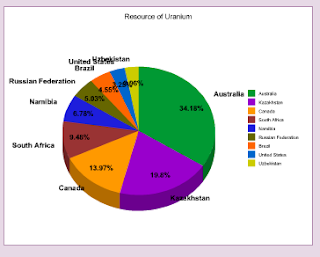
9. Uranium.
10. By improved prospecting
11. Australia had 164.4 million hectares of forest. There is 162.7 million hectares of native forest area. Plantation forest had 1.7 million and less than 1% of native forest is harvested.
12. It is valuable because it is a very good power source but it can also be used for nuclear weapons. Millions of dollarts are put into the Australian economy through uranium exports.
13. They attract large numbers of tourists to Australia which benefits Australia's economy.
14. It can be bad because Aboriginal sites have been destroyed through uranium mining. This is bad because I respect the people that were he before us.
15. The fishing zones are mainly around the coasts and around the External Territories the Australia own.
16. a. The uranium mines are all around Australia but there are more on the western side of Australia and more north in Northern Australia.
b. Radium Hill
c. Ranger
17.
18.a. i. $300 million
ii. $250 million
iii. $550 million
b. $382 million
c. It starts of at about average goes up and then back down and then it hits its highest ever.

Tuesday, March 15, 2011

The Earthquake and Tsunami in Japan

1. The epicentre of the earthquake in Japan was just of the East coast of Japan, east of Sendai.
2. The earthquake was 8.9 on the richtor scale.
3. The most affected area is the city of Sendai and towns around it. Thousands of people had died and thousands are missing. And hundreds of thousands of people are homeless.

4. A nuclear power plant in north-eastern Japan was destroyed and now radioactive materials are leaking and the radiation can kill people.

Monday, March 7, 2011

1.7 Questions - Australia's unique flora and fauna

1. Australia has been isolated from the rest of the world for 50 million years. This means that Australia has evolved differently.
2. Many species have survived for millions of years because of the stability of the continent.
3. Endemic is a species that is not found anywhere else in the world.
4. 89% of Australia's reptile are endemic.
5. The Great Barrier Reef, the tropical rain forests of Queensland and the south-west Botanical Province of Western Australia.
6. The tropical rain forest is the richest insect fauna of any area of the country.
7. A marsupial is an animal with a pouch. An example is the kangaroo.
8. A monotreme is an egg-laying mammal. An example is the echina.
9. Wallabies are generally smaller than kangaroos and prefer more rugged terrain.
10. Platypus' are monotremes and are endemic to Australia. They spend 12 hours a day swimming and searching for food. Their bill if very sensitive. The nostrils are on top of bill. Its eyes are closed underwater and it uses its bill and nostrils to find food.
11.

Wednesday, March 2, 2011

Questions 1.6

1. Climate is the pattern of weather that is expected in a particular place. Patterns of climate and vegetation are closely related because climate is the main factor that determines where plants can grow. Weather is short term and it is what is happening in the present time.
2. The Earth receives more of the Sun’s energy at the Equator than at the poles so temperatures are highest at the Equator and the temperatures decrease as latitude increases.
3. Typical summer weather map - low pressure in the north, high pressure in the south. Typical winter weather map - high pressure in the north, low pressure in the south.
4. Currents - Currents from nearer the poles bring cooler conditions and those from nearer the Equator bring warmer conditions.
5. Temperature decreases with height. Moist air that is forced to rise by mountains cools, and the water
vapour condenses, producing increased cloud cover and precipitation. Highland areas are cooler and wetter
than lowland areas.
6. a. Average climate statistics assist farmers to tell them when it is most suitable to plant their crops as they may want to plant them the month before a huge rainfall occurs. This also helps determine when to harvest their crops. For example you may need to plant in winter and the best time to harvest is the first of spring.  
b. Tourists may want to look at the forecast/ climate predicted if they are considering going away to a sunny place as they don't want it to rain.
7. Where there is a lot of vegetation, forest and woodland can be very hot and humid. Then there is the places where there is only a bit of shrub land, pasture and cropping and this is where there is sub tropical conditions, hot dry summer, warm dry winter.
8. a. Hobart- average of precipitation is 47.43 rainfall (mm) and the average temperature is 12.41 Celsius.
b. Darwin- average of precipitation is 142.4 rainfall (mm) and the average temperature is 27.59 Celsius. 
9. a. Alice Springs has the greatest temperature range as shown in source 1.29.
b. Melbourne has the most seasonal rainfall as by average, Melbourne is around 50 mm and Alice Spring is close to 30 mm of rainfall.

Tuesday, March 1, 2011

Viktor Reznov - Moscow, Russia

Sydney's Highs Lows and Average Temperatures
The weather is going to be a lot different to what you get in Moscow, Russia. As you can see on the graph the average temperatures will be low twenties and high teens. You wont need any of your snow jackets because it wont be snowing at all. As you can see below your temperatures are freezing compared to our temperatures in Sydney.


These graphs show the average precipitation in Sydney. Below shows the average precipitation for Moscow.
But during your stay you will be going to Thredbo. In Tredbo it is very cold so maybe you should bring your snow jacket.
The clothing will be different in Sydney but in Thredbo the temperature will be cold but not as cold as Moscow. You will need t-shirts, shorts, snow jacket, jumper, thermals and long pants of some sort.
See you soon,
Matt

Friday, February 25, 2011

1. The Western Plateau, The Central Lowlands, The Eastern Highlands.
2. The Australian Alps are situated from the Brindabella Range north of Canberra to the Baw Baw Range east of Melbourne.
3. The Australian Alps are rounded in shape because of millions of years of erosion and weathering.
4. Uluru is located 335 kilometres south-west of Alice Springs in the Uluru-Kata Tjuta National Park.
5. Uluru is a massive rock composed of red arkose, a coarse sandstone, that stand 340 metres above the surronding plain. It is 9.4 kilometres around the base and extending for several kilometres underground.
6. It glows red at dusk and dawn because of the positioning of the sun, when it has more atmospheric particles to travel through to hit the rock. The sun's rays change colour the more particles it has to go through. At midday the suns rays haven't got to go though as many atmospheric particles.
7. A drainage basin is an area of land that is drained away by a river and its tributaries. 
8. The Murray-Darling and the Lake Eyre Basins.
9. The Murray, Darling and the Murrumbidgee Rivers.
10. Most of the water disappears through evaporation.
11. The Finke River is the oldest river bed in the world and only flows a few days a year.
12. The Franklin River flows from the Cheyne Range to the Gordon River in Tasmania. It has become synonymous with conservation because the 'Battle to Save the Franklin' rescued it from major damming.
13. In July 1983 there was a High Court ruling that gave the Commonwealth power over the states and territories to protect nationally important environments.


14. The Australian Government should have control of the water because if it is over-used then the river will dry out and natural habitats will die out because there is not enough water for them to survive. The Murray-Darling Basin is very important: It contributes to about 40 percent of Australia's total agricultural output annually, it contains 70 percent of Australia's irrigated farmland and it supplies drinking water and domestic water for 2 million people. This is why we don't want the MDB to dry out.
15. a. The Western Plateau takes up all of Western Australia, all of the Northern Territory, most of South Australia and a small amount of New South wales. The Central lowlands is in Eastern Queensland, New South Wales and Victoria. The Eastern Plains takes up most of Queensland, about half of New South Wales, half of Victoria and all of Tasmania.
b. i. Western Plateau
ii. Western Plateau
iii. Central Lowlands
iv. Eastern Plains
v. Central Lowlands
c. i. Mount Woodroffe
ii. The Simpson Desert
d. i.0-200 metres above sea level
ii. 200-500 metres above sea level
iii. 200-1000 metres above sea level

Sunday, February 20, 2011

1.4 Questions

1. Continental drift is the movement of the Earth's continents.
2. The tectonic forces associated with plate margins that are responsible for creating major landform features.
3. Rodinia
4. Pangaea existed about 300 million years ago.
5. South America, Africa, India and Antarctica.
6. Australia is moving about 5cm north every year.
7. Less than one million years ago.
8. The main agent of erosion is aridity water.
9. The study of landforms.
10. They determine the processes that form and transform them.

Thursday, February 17, 2011

Write a blog post explaining the positive and negative aspects of Australia having a long coastline and large EEZ. (give at least 5 dot points for each advantage/disadvantage)


  • An advantage of a large coastline is easier shipping and trade. This is because you can get closer to a destination.
  • Another advantage is fisheries get good business.
  • A disadvantage is more people need to guard the coastline to stop: attacks, asylum seekers and illegal fishing.
  • Its easier to get to other places because its not land locked with another country.
  • A disadvantage of a large EEZ is that it can start a dispute about who owns what part of the ocean.